vGIS Utilities
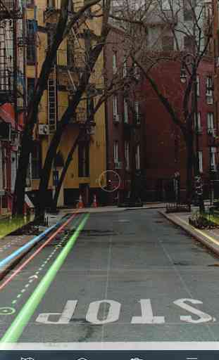
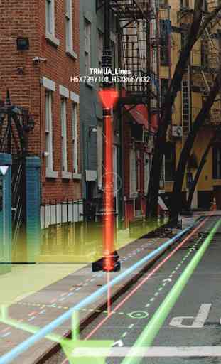
Using the vGIS system, field personnel can see an augmented view that includes holographic infrastructure objects, improving their environmental assessments and increasing their situational awareness. From delivering real-time, in-field holographic visualizations of underground pipes, valves, cables and other utility objects to visualizing ground penetrating radar scans, vGIS solutions are estimated to prevent 25% of excavation-related accidents resulting from human error, among other benefits.
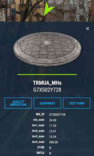
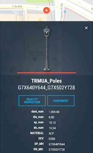
The system combines object holograms with object-specific data to provide a hands-free method for field technicians to understand the infrastructure they need to service while on site, quickly and safely.
Key features:
• Exceptional Accuracy
• Consistent Visualizations: 3D overlays stay “world-locked” by remaining in sync with the physical world
• Multi-Device Support
• No Additional Equipment: vGIS Utilities does not require any additional equipment
• Workflow Integration: vGIS Utilities integrates with your existing back-office systems
• Advanced Collaboration: Integrated holograms, video, and audio that connect the office with field teams
• GIS Integration: Bidirectional integration with Esri ArcGIS and other GIS systems
• GNSS Integration: Integrates with high-precision GNSS devices from EOS, SXBlue, and Trimble
• Multi-View Support: First-person on-site experience and birds-eye “zoom out” site overviews
• GIS Object Support: Supports visualization of points, lines, areas, volumes, and 3D objects
• 3D Object Support: Natively displays objects from Esri CitiEngine and Trimble SketchUp
Category : Productivity
Related searches
Reviews (5)
W. W.
Aug 22, 2021
Wasting of time. Know it's not even free to try after installed.
Mar. V.
May 13, 2021
No information provided about required subscription services
Nas. A.
Mar 5, 2021
There must be a trial at least for 7 days to use the App by uploading and viewing our own Utilities data
Mik. C.
May 21, 2018
vGIS is a great application to view your utilities GIS in an augmented reality.
The app says to contact support for a Trial code. However no code is provided unless you speak to the sales team.