ViewRanger - Trails & Maps
Used and trusted by over 250 search and rescue teams.
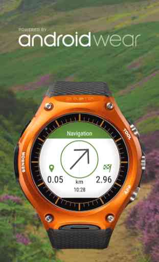
ANDROID WEAR™
• Navigate your trail and view track stats on your wrist with Android Wear™ enabled smartwatches.
• Record a new track and pause or stop an existing track recording.
• View Heading, Bearing, Lat/Long and Altitude data.
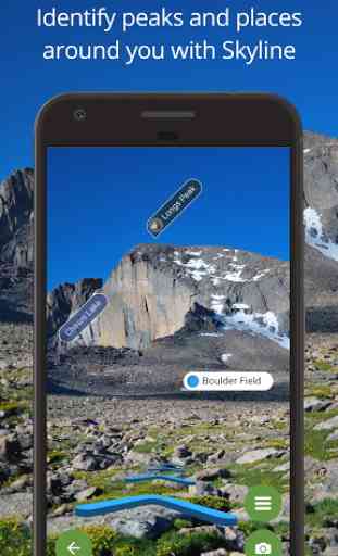
SKYLINE: AUGMENTED REALITY FOR THE OUTDOORSBring your outdoor map to life with Skyline, our new augmented reality technology. Using the iPhones camera it will identify key features around you such as peaks, places, google trends and lakes. Skyline helps you navigate too. See waypoints and follow direction arrows for routes on the real landscape. (Note: No Skyline coverage in Alaska)[Skyline requires devices with GPS capabilities, phone camera, compass, and gyro sensors. Compatibility with Skyline is not guaranteed.]
FEATURES:
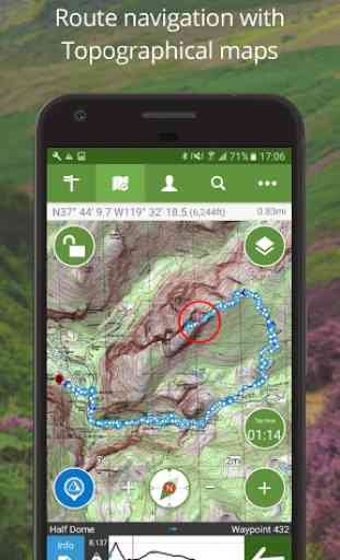
DOWNLOAD USGS TOPO MAPS & MORE: USA topo map; OpenStreetMap®, OpenCycleMap, Bing Aerial Imagery Ski piste map and transport maps.
PLANNING A TRIP ABROAD? WE HAVE YOU COVEREDDownload the best topographic maps for your travels across many countries in Europe, North America and also New Zealand. See the full list of countries in the map shop.
ACCURATE OFFLINE NAVIGATION: The app uses your device's GPS, and does not need data or mobile signal to locate you on a map, record your track, or follow a route. Maps are stored on your phone so they work offline.
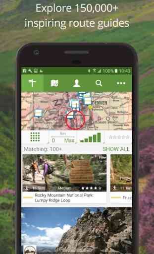
DISCOVER INSPIRING TRAIL GUIDES: Create and follow your own routes or download routes from our massive library of expert
- and community-generated walks and rides. Discover routes from leading publishers such as Backpacker and Elevtion outdoors.
RECORD YOUR ADVENTURE: Record your track, see your track live on the map as you advance and share the completed track with friends; view track stats such as distance, speed, altitude and many more.
SHARE YOUR LOCATION: BuddyBeacon™ is a unique PIN-protected real-time location sharing and tracking system which allows you to share your location with friends and family.
-------------------------------SUPPORTNeed more info? visit: http://www.viewranger.comSupport page: http://www.viewranger.com/en-us/supportAny questions or feedback, please drop us an email: [email protected]
OTHERFree Global maps © OpenStreetMap contributors.Continued use of GPS running in the background can dramatically decrease battery life.Some features such as BuddyBeacon, viewing online maps, browsing route suggestions, downloading maps and routes requires an internet connection.
Category : Health & Fitness
Reviews (23)
Like others, I'm extremely annoyed over the closure of ViewRanger. I've spent a lot of money over the years buying os maps for it and I do NOT want to have to subscribe to see them. I dislike the 'new' app! I'm moving to the Topo-gps app. Their subscription cost isn't too bad and you can also buy OS maps to download with out signing up. It's interface is a bit more clunky than viewranger and the marker arrow too simple, but it seems really light on battery use. Locus was too sub based.
I thought I should write a review now that Viewranger is being forcibly taken away from me. Viewranger isn't perfect, but it is close to perfection for me. I have invested a large amount of money on maps over the years and did feel it was money well spent. I could use the app offline, store all my maps on a card and it never failed. The sad replacement (OA) is simply nowhere near as good. Yes, I might be able to migrate my maps, but that is of no benefit if the app is unusable.
The 2 most important things for me are having an offline OS map of Scotland and altitude readings and Viewranger has both thus gets a 5 rating. I've tried about 20 other apps and can't find one that has both of these things thus I will probably have to use a combination of Memory Map (offline OS map of Scotland) and Alpine Quest (altitude readings). Outdoor Active has neither of these things (and is lacking in other things also) and would get a 0 rating.
Very pleased with this app. Easy to use, particularly like the 3d function. Review after takeover. Very disappointed that viewranger has been taken over, renewed my subscription only to find that most of the things I use, 3d etc are only available on the pro version at a significantly higher price. Not impressed and will not renew again
By far the most user friendly mapping/navigation site The ability to purchase, download and hold for use anywhere OFFLINE quality survey maps of many European countries is its greatest plus in my opinion. Colleagues who have been "bullied " into shifting their account to Outdooractive are finding this to be an unpleasant and in many cases unworkable option. Is ViewRanger really going to close down??
I don't get why so many people have given 5 stars after being left hung out to dry. I purchased so many map tiles in 2021 to do a tour of North West Scotland... now all gone! There is something in what is suggested by some to switch off WiFi, don't update. I found that my old phone still holds the tiles I purchased up to 2020'ish, it's something, I just need to see if I can transfer or copy the memory cache which is what I used to do on my old android phones.
The dreaded day has finally come. ViewRanger is no more. Time to uninstall the app and move on (but definitely NOT to Outdooractive). The ViewRanger web site is still up but you are redirected to Outdooractive to view anything. I guess I will download everything I've recorded and delete my account. Bye ViewRanger, you will be missed!
ViewRanger Springs eternal! All may not be lost, for some Android users at least. Probably wisest to switch off the internet - THEN fire up VR, don't renew licences; ignore the splashscreen's invitation to install OA, just hit the return button. If VR doesn't disappear in a puff then you might be back with our old friend. Good luck.
View Ranger is no longer a functioning app. It opens a window to download a different app called Outdoor active. That's all it can do, that's all it is made to do. As of today it has zero functionality. This should be deleted or flagged in the app store as permanently defunct. Do not download it. It was good, back in 2020.
Excellent app, particularly for older phones. I have used it a lot for cycle touring and it has never let me down. A shame it's being discontinued and replaced by Outdoor active which is nowhere as good at the moment. I will need to find another navigation app.
Paied for the Pro version. Tried many apps of this kind. Vieweranger is the best of all, and hope they won't discontinue. Outdoor Active that is supposedly some upgrade... is only a very poor imitation.
KEEP THE APP GOING PLEASE DO NOT TURN IT OFF Viewranger is way better than Outdooractive. If you turn it off, please give me my money from credits back. An excellent app (going down by joining Outdooractive). They have stopped allowing to buy credits so cannot buy OS maps any longer. Very disappointed. And, Outdooractive is a much inferior app!
Soon to be forced to migrate to outdooractive where £100+ of purchased offline maps will no longer be usable. Instead it is required to pay a subscription for the same functionality with arguably poorer features. Viewranger was awesome, shame to see decisions like this being taken. As a burnt legacy user I'll seek another app from a less sneaky developer.
Allways money, money, greed. Whenever I find a really good app, such as this one, after some time app is closed, or migrated to something poor and almost unusable such as Outdoor. ViewRanger was great, with lots of free maps, beautifull screen look and feel, nice topo markers, free offline area download possibility.. I tried migration to Outdoor map and it is poor experience, looks and feels nowhere near good as VR. Same happened with Endomondo app. Greed, money.. Please dont shut ViewRanger.
Love this app, best walking app out there, it was great to get selected walks based on your usage and downloads, that may suit you. Also had the option to purchase the OS maps for your walk.
This app has been great. I reverted back to an older version v8.1.28 as this uses Skyline for free and still allows you to select individual map tiles to download from the free cycle map which are perfect for every day use. (Also backed up app for future use so that I can always reinstall). For now, as I write, all the key features still work in Viewranger that are essential and unless the new owner 'Outdoor Active' drastically changes, will not consider moving over to their service.
Bye bye Viewranger... it was lovely knowing you! I'll miss: * being able to look at any part of the UK, at any time, from anywhere, offline. * planning routes easily & accurately without having to download a bloatware map first * planning big routes that don't fit into OA's piddly max d/l map that eats 1Gb of storage every time * not having to consider what will happen to my currently free Pro+ Outdooractive subscription when OA decide it's time is up...
ViewRanger is the best and using it more than 3 year todate without any problem. Try to use Outdooractive but the apps is not comparable user friendly. Need to find new apps as capable as ViewRanger.
Excellent app. Used extensively on hikes and runs over the years. Sad to see it being switched off and replaced by the objectively terrible OutdoorActive (1.6 stars! 😭)
Like 100's of previous reviewers I found Viewranger brilliant, absolutely loved it. I've tried Outdoor Active and found it unusable, I totally resent being forced to use it, and like a previous reviewer, I will be moving to Locus Maps.
This is an excellent app which I've been using since I had a Symbian phone. I'm so sad that the new owners don't see it that way and want to force users to switch to the inferior and bloated OutdoorActive. It's OutdoorActive users who should be moving to ViewRanger. I have tried several times to engage directly with OutdoorActive support over essential missing features in their app and "End of Life" policy, but the responses have been limited at best, causing a loss of trust on my part.
I'm a bit torn about this review. I've used VR for a number of years now and it's easy to use and feature rich. However, there's a catch, and it's called outdoor active. Since the merger, features are dropping off and the suggestions direct the user to outdoor active, which is not as user friendly and nowhere near as good. It's a real shame as I've thoroughly enjoyed Viewranger but when it's fully absorbed by outdoor active I'll be looking elsewhere.
Editted. Sold out to outdoor active. I left a damning review on that app but it seems to have been removed! Basically they have taken our money, have good service but then told us they were stopping. Can't see my OS tiles any more. Cheated. Original text, no longer relevant: Been running this for years and I use it weekly. An improvement would be to follow roads or paths when plotting routes (as available on full web version)