Washington Geology
Have you ever wondered if the café you were sitting in was in turn sitting on the Osceola Mudflow? Have you ever seen a rock outcrop in North Bend and wondered what it was made of? Do you want to map out your tsunami evacuation route for an upcoming trip to the coast? Have you reached the job site in Seattle and forgotten critical boring log data? Have you ever lost a bet with a friend about the age of the Spirit Lake Pluton?
Now you can explore Washington’s geology, learn about geologic hazards, and find borehole lithology data all from your mobile device.
This app is a much-simplified beta version of the Washington Geologic Information Portal, a desktop-based interactive map containing detailed and comprehensive geologic data about Washington State. This app is ideal for geology students, professionals, and those familiar with geologic terms and concepts.
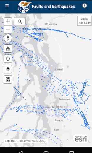
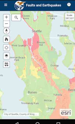
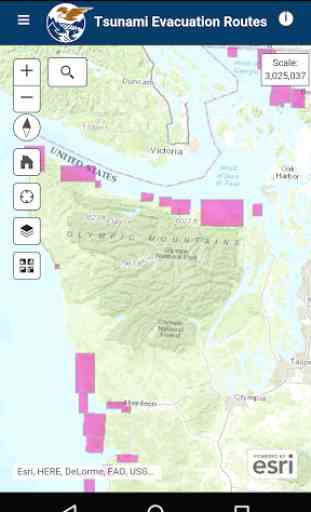
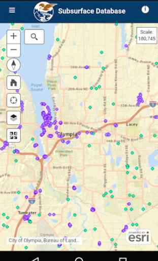
Available Layers:Surface Geology at 1:500,000, 1:100,000, and 1:24,000 scales and geochronology dataTsunami Evacuation: including: assembly areas, local landmarks, evacuation zones, and map boundariesSubsurface Data: geotechnical borings and water wellsFaults, Earthquakes, and Tsunamis: active faults and folds, trenches, earthquakes, liquefaction susceptibility, seismic site class, and tsunami inundation modeling
Note: This app requires an internet connection to display data, and data charges may apply. Geolocation services are enabled in order to display device location on the map, but the data is not collected or saved.
Desktop version: http://www.dnr.wa.gov/geologyportal Visit our website: http://www.dnr.wa.gov/geology Or our blog: https://washingtonstategeology.wordpress.com/
Now you can explore Washington’s geology, learn about geologic hazards, and find borehole lithology data all from your mobile device.
This app is a much-simplified beta version of the Washington Geologic Information Portal, a desktop-based interactive map containing detailed and comprehensive geologic data about Washington State. This app is ideal for geology students, professionals, and those familiar with geologic terms and concepts.
Available Layers:Surface Geology at 1:500,000, 1:100,000, and 1:24,000 scales and geochronology dataTsunami Evacuation: including: assembly areas, local landmarks, evacuation zones, and map boundariesSubsurface Data: geotechnical borings and water wellsFaults, Earthquakes, and Tsunamis: active faults and folds, trenches, earthquakes, liquefaction susceptibility, seismic site class, and tsunami inundation modeling
Note: This app requires an internet connection to display data, and data charges may apply. Geolocation services are enabled in order to display device location on the map, but the data is not collected or saved.
Desktop version: http://www.dnr.wa.gov/geologyportal Visit our website: http://www.dnr.wa.gov/geology Or our blog: https://washingtonstategeology.wordpress.com/
Category : Productivity
Related searches
Very handy app. For one thing, it works (Samsung S4, Verizon). It has basic data for surface geology from DNR's 24K, 100K and 500K maps, essentially the same stuff you get in the online app or in the KMLs you can download from the DNR site. Also has a big database of well logs for subsurface geology, with links to online reports (a few links would be nice in the surface geology layer as well, but no such luck). Has the usual ESRI basemap options and it geolocates properly. Also has a geochronology database, but again, the data are sketchy and there are no links for further information.