WBMIFMP- Irrigation and Waterways Department
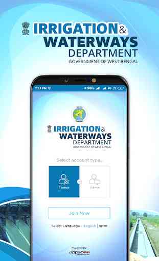
The WBMIFMP application, developed by Appsbee Technologies for the West Bengal Major Irrigation & Flood Management Project (WBMIFMP) under the Irrigation & Waterways Department (I&WD), Govt. of West Bengal, is the first ever application to water management through scientific data collection, dissemination of information on water availability within all blocks under the Damodar Valley Command Area (DVCA) in the districts of Bankura, Purba & Paschim Bardhaman, Howrah and Hooghly. It is people and farmers tool (Mobile App) as information on water can help in predicting water availability and help farmers to plan their crops and other farm-related activities.
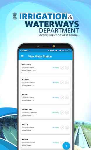
With the help of this tool, the real-time water level data at different Canal structures/regulators (Water Station) can be monitored/checked & analyzed from anywhere & anytime during the supply of irrigation water to the Farmers for Khariff, Rabi & Boro cultivation. All the valid and justified queries of the Farmers in the command area, related to availability & water schedule will be sorted & answered via the Mobile App, instantly. This tool will help the management & operators to monitor the critical parameters of the Canal System on real-time basis & accordingly supports precise decision making.
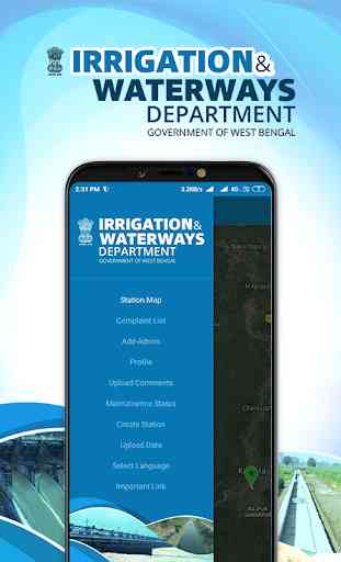
The WBMIFMP application will prove to be a one-stop solution to most of the water stations where it will not only monitor the required water levels with the actual water level but also be the grievance unit for all the farmers and people connected to these stations. It provides a digital platform for both the administrators as well as the farmers of this area to connect digitally and communicate necessary information and fix any hindrances faced during the functioning of these water stations. A maintenance status feature allows the users to see how well the water station is being maintained and also keeps a check on the grievances being solved and looked up to. This application not only serves the purpose of determining water levels of a particular station but also shows what type of crop is grown using the reservoir water thus facilitating irrigation at its best.
WBMIFMP aims at raising the degree of quality of these water stations with regular checks, timely maintenance and looking into each complaint with utmost scrutiny and concern. The application provides a map showcasing all the water stations through map pointers of green and yellow color. The color holds significant importance as green color indicates a situation where the actual water level is more than equal to the water level required whereas the color yellow demonstrates a situation when the actual water level is less than the water level required, making it very easy for the administrators. The application can be operated in English as well as the Bengali language, making it easy for the locals of the particular district thus eliminating any language or communication barrier.
Appsbee Technologies has developed and designed the WBMIFMP application from the scratch maintaining discretion and sincerity, with a perspective of solving major water station hindrances, maintaining a quality standard, demonstrating all the relevant information and acting as a mutual platform for farmers and administrators to connect and communicate.
With the help of this tool, the real-time water level data at different Canal structures/regulators (Water Station) can be monitored/checked & analyzed from anywhere & anytime during the supply of irrigation water to the Farmers for Khariff, Rabi & Boro cultivation. All the valid and justified queries of the Farmers in the command area, related to availability & water schedule will be sorted & answered via the Mobile App, instantly. This tool will help the management & operators to monitor the critical parameters of the Canal System on real-time basis & accordingly supports precise decision making.
The WBMIFMP application will prove to be a one-stop solution to most of the water stations where it will not only monitor the required water levels with the actual water level but also be the grievance unit for all the farmers and people connected to these stations. It provides a digital platform for both the administrators as well as the farmers of this area to connect digitally and communicate necessary information and fix any hindrances faced during the functioning of these water stations. A maintenance status feature allows the users to see how well the water station is being maintained and also keeps a check on the grievances being solved and looked up to. This application not only serves the purpose of determining water levels of a particular station but also shows what type of crop is grown using the reservoir water thus facilitating irrigation at its best.
WBMIFMP aims at raising the degree of quality of these water stations with regular checks, timely maintenance and looking into each complaint with utmost scrutiny and concern. The application provides a map showcasing all the water stations through map pointers of green and yellow color. The color holds significant importance as green color indicates a situation where the actual water level is more than equal to the water level required whereas the color yellow demonstrates a situation when the actual water level is less than the water level required, making it very easy for the administrators. The application can be operated in English as well as the Bengali language, making it easy for the locals of the particular district thus eliminating any language or communication barrier.
Appsbee Technologies has developed and designed the WBMIFMP application from the scratch maintaining discretion and sincerity, with a perspective of solving major water station hindrances, maintaining a quality standard, demonstrating all the relevant information and acting as a mutual platform for farmers and administrators to connect and communicate.
Category : Tools
Related searches
Reviews (2)
Isr. M.
Jul 31, 2021
There is login problem..App is not working.
Good concept and initiative by Government. Will be very helpful.