Wildfire Info
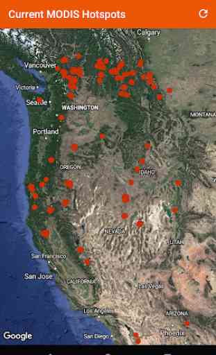
Thermal hotspot maps by region show wildfire activity in the past 48 hours from the NASA MODIS and VIIRS satellite instruments. Tap a pin to show detailed hotspot info including fire radiance power and brightness temperature. All data is timestamped in UTC. Different days in the 48-hour window are broken up with red and purple pins for easy viewing.
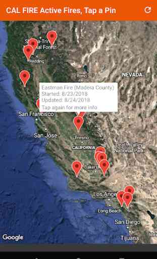
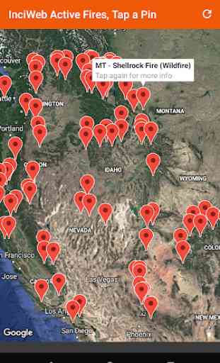
InciWeb & CAL FIRE active fire maps: tap a marker on these maps to go to the corresponding official incident webpage.
An aggregated news wire service for wildfires only: find mainstream media news quickly, past six hours of headlines and links.
Easy access to the corresponding InciWeb Incident or Article webpage.
The InciWeb Incidents feed is categorized by state. The InciWeb Articles feed is in chronological order, with incidents tagged by state.
Tap a fire in the InciWeb Incidents Feed to zoom to it on a Google Map.
There is a section for wildfire-related Twitter accounts, sorted into national and state sources.
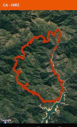
View current infrared GeoMAC Active Wildfire Perimeters data. All perimeters are selectable from a national listing.
Information is posted as soon as it becomes available from GeoMAC, NASA, InciWeb, and CAL FIRE.
This app is not affiliated with any government agency.
There is a fixed banner ad from Google on the bottom of some content.
Category : Weather
Reviews (30)
I'd give the app a lot more stars if it didn't shut down almost every time I try to look at anything. Doesn't seem to matter which modality I select, the app stops working. When it _does_ work, it's very handy, but I can't rely on it and that's a deal breaker. I'll keep it installed for a while but will be shopping for a different app in the meantime.
I wanted to like this. It has good source data, but it's all disaggregated across a bunch of menus. Too difficult to navigate and I don't know where to find different parts. I'd love to have an app that just has one map with layers that show perimeters, evacuation zones, containment info, etc. This unfortunately doesn't have that.
Update: The perimeter is a feature that doesn't contain all active fires and can takes DAYS to show an active fire, which renders it useless to me. Currently, the IRWIN screen doesn't even show the "Sites Fire" which is an active fire in CA of 1,000+ acres. So I can't tap on it to see a perimeter. Again... USELESS. This is a honest review. I'm sorry if the the app dev doesn't appreciate honesty.
I HAD InciWeb app when I had an iPhone and found it so helpful since I have 2 homes both in red flag areas. I was disappointed that I couldn't find that app on android. So all week I have had so much trouble dealing with the Bobcat fire, are we supposed to evacuate or not, not many updates, confusing. Decided to open this app and right there before my eyes was InciWeb. Now I will always be up to date. I haven't checked yet to see if it covers Flagstaff but surely hope so..
was working fine last year, now cannot access CAL FIRE active fires map, and I just had 2 fires very close to home and evacuated but could not get updates, please fix. 8/26 = Thanks for the update, I will definitely give the app another go.
This app attempts to serve as a one-stop link shop for related websites (CalFIRE, inciweb, GeoMAC), twitter accounts, and maps. Since twitter feeds are usually more up-to-date than the website, I really appreciate this feature. Great app.
Very detailed. No crashing. Android 11. **Hey everyone!?, how about a simple THANK YOU DAVID for the FREE app which took probably hours/days/weeks to develop. 1&2 stars should be for paid apps. Thank you David for your work, and trying to help others be informed about the wildfires. Much appreciated !😊
Used to work but now crashes every time the inciweb map is clicked. Android phone. Sent feedback days ago. Still crashes.
I'm trying to see a fire that is going towards me, im going to need to evacuate very soon, this doesn't help at all. Around the El Dorado fire, sorry for the review :( | Edit: changed review, maybe add a button to go to current location? Sorry for the inconvenience | Edit: okay, makes sense, sorry :/
Gives status of fires around the US. Updated fairly often.. If you travel a lot, planning your drive to avoid closures & restrictions is a must.
Very responsive developer. Not his fault that the map sources themselves are out of date. Fortunately there is a coming feature to make maps up to date quicker (I won't steal his thunder).
It is useful but wish it would combine modis heat detections with wildfire peremiter and incident name layers into one screen like GeoMAC . Overall good start and has potential.
This app has a lot of potential, so far but, I couldn't find an actual boundary of the fire area. So I'll be checking back in about a month and see how this app is progressing. reg camp fire CA.
One of my kids live in California. So, this Wildfire Info App is very Vital & Informative & Highly Important for me to have & use to keep me ALWAYS UPDATED ON ALL CALI FIRES at All Times. Glad to have this App installed on my Android. I love this App.
Trying to install to a S10+, getting error, unable to install Updating review as the developer is extremely awesome on support, app is still not installing, but working on how to fix it.
I just wish it would show fire perimeters (plural) on a map. Until then it's not useful to me, but 4 stars for having tons of info
This app is the best starting point for wildfire info anywhere in the US. And it links to sources with more info. Must-have app for wildfire season.
Bloody amazing app, it shows local and official fire departments, forest and wildfire support and response departments also, gives pleanty of info on the current ans outdated fires, i wouls use this app wherw or whenever i need it
Great app, keep up the good work this is super helpful in keeping a Southern California's with just a piece of mind.
I love this app. One issue I have, though, is that it doesn't update the containment number for the El Dorado fire
You just have to learn where everything is this is one of best app out their. This is really a great app just play with it !!!! Just full of information.
Ever option crashes! Worked when first downloaded but next day every option crashes the app.
Great app to use and locate fires. We use it most when traveling
I'm giving 5 stars knowing that this developer is so dedicated and extremely attentive in making his app work for the users. He deserves the highest praise for app maintenance.
Works fine on Android 9, but InciWeb is the only map showing the massive Beckwourth/Sugar fire in California that's been burning for over a week.
Great App! Could be a bit more user friendly but overall gives a ton of detail
Hi. So, every time I tap on Calfire, the app crashes.
Love the motherlode of info. Easy to navigate even for this granny who is very tech savy.
The amount of information at your fingertips with this app is the best. Thank you very much to the team!!!
If you are a fire tracker or into public lands this app is indespensible. It brings all the fire tracking websites into one accesable app.