Windy Maps
Key features:
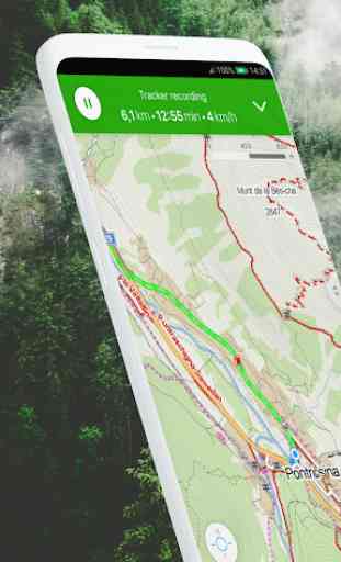
• Most detailed world maps with tourist trails, bikeways and ski pistes
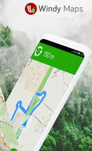
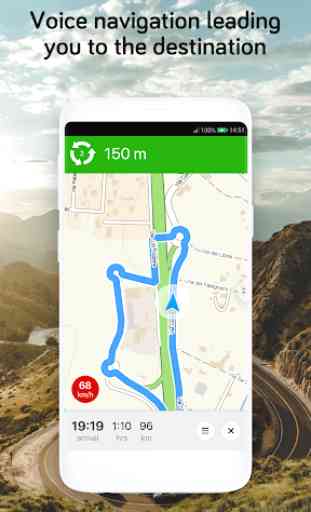
• Free voice navigation for riders, bikers and hikers in English. You can also use TTS voice.
• Turn by turn car navigation, bike navigation, walking directions
• Travel tips in your surroundings
• Offline route planning with altitude profiles
• Offline search places, coordinates and categories including open hours and contacts
• Measuring distance by two fingers on the map
• Submitting photographs of places
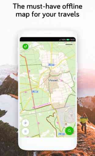
Even offline you can:
• Use downloaded maps or regions
• Search locations all around the world
• Find the route and navigate at places without internet connections
You will enjoy this app!
Category : Maps & Navigation
Reviews (21)
I don't often rate apps, but felt compelled to do so for this one. No ads, great-looking maps full of valuable information on hiking trails and local points of interest - even in not-so-touristical places! I use it all the time when visiting new places and recommend it to anyone. Big kudos to the devs 👍
Good and it's free! I will give 5 stars if have all the gravel bike trails, bike lanes, and more options of how to custom bike routes such as easy ride and avoid busy traffic roads. Plus need to have more options of choosing different types of bicycle such as gravel, city, etc.
Fantastic app ! Simple, fast, even better than Viewranger for my needs. I downloaded lots of hiking apps to replace Viewranger as it's being stopped and replaced by OutdoorActive which is a poor replacement. All of them were disappointing. Luckily I found Windy Maps. You can download offline apps to use the GPS when you have no signal. It has the pointer arrow that shows you which way you are going when you get lost.
I really love this app! Thank you! The only suggestion I have is to make the opportunity to save planned routes, it usually takes a lot of time to plan them abd would be nice not to do that several times more. :) PS: I also noticed some mistakes: for ex. on the map I see 3 lines - blue, red and yellow, while in reality there is no yellow route at all. I noticed it about two times (Hungary). If you need my help to correct them, I can send the pics
Love it! so much more detail than Google maps. wish I could add things when I am offline though. as cyclist we really need to know if a town we are going to have somewhere to stay in or not, so I would like to add guest houses as I go past them, but I can't since I need WiFi for that to be possible. would be great if I could add off line and then the additions are sent when I get WiFi. I have not figured out how to save routes. some more instructions would be useful.
Nice easy to use app. I like the weather integration. An option to change "Guidance Volume" would be nice. Now I can hardly hear it. Using offline maps. Edit: Really sorry to say but from 5 to 3 stars. This is why: After first cartrip I have to say that guidance was sometimes really too late. For example: voice guidance after I already made a turn. Another time: lane guidance came way too late.
Overall very strong offline map. I take one star off the rating due to these: 1.Some parts of the UI are not very intuitive, e.g. a. you can't specify a FROM point to start the routing process, so everytime you have a calculate the route from where you are. b.select something and single tap on something else will not cancel the selection 2. The size of the maps are too big. Etc. 3. No night mode outside the navigation mode. Happy to raise this to five starts if the developer can fixed these.
We used this to do (and still are ) a cycle tour throughout France . It's really easy to use and works well in my very cheap Android phone . Battery usage is good and the maps are easy to follow in navigation mode . Usually turn off the voice but that is useful when driving our car because of the higher speeds and workload involved. had a few times when lack of resolution has caused confusion at junctions but this may be the GPS on my phone. Cycle routes shown better than Google Maps.
For my use its the best app for hiking navigation. Very easy interface, includes altitude lines, all the routes you'll find in Google maps and also has a start-to-end navigation feature with an easy to understand height difference display. The only thing I find missing is a tool to save favorite spots on the map like the hotel I'm staying in or an entrance to a park I want to view letter.
It's a really good hiking app. Used it so many times. It's good for planning and using for real time hiking map just like a gps. You can save your routes!!! And it's free app!! Advice to developers: 1) A compass on the main screen where the maps is would be great specially when the internet is not that accessible and the pointer isn't that accurate.
It will be good if the map has grid lines. It does not offer measuring tools. Edit: Utilising fingers makes it difficult to see the distance. Not all trails are straight lines. I believe this app has large potential if integrating grid lines like the paper maps. Edit: Is it possible to get an overlay grid? Pinching is kinda inconvenient...
This app has beautiful Maps, but being from Windy, I was expecting a lot more. When you are great, people expect nothing less than greatness. I use the app for hiking and I would find it helpful to see fences, like I have seen on a different app. Also there are path lines everywhere, but nowhere I could find a legend to see what they actually mean. I have searched online, but I was not able to find anything. Looking for improvements.
Awesome. Best Hiking map for Android. Never failed me so far. Easy route planning. Not draining too much juice. Everything , and i mean everything is on this map. Even my paper maps for my area don't contain so much detail. 6+ stars. And one more thing. The app is not bombarding you with ads. I mean, every developer should take notes.
Use this primarily for walking and cycling. I used to use Maps.me but there the maps became less detailed and the app more commercial. In this app the maps have show much more detail (although that does make it slightly laggier but it's ok), the (cycle) routing is better and for being free with no ads it's amazing. I hope this app stays as good as it now is; it probably won't but I hope it does. I'd gladly pay for this app
easy to use with downloadable Open Street Maps. Seems to only have one map type which is ok but the red long distance paths can be overbearing in some places. Navigation can be switched between transport modes with a choice of road cycling on very fast roads or mountain bike for a more tortuous route. No navigation apps are perfect!
Good app, however I'm still not able to change the measurements to miles and feet. I have logged on to the Windy weather app and successfully changed the units to feet and miles. Once logged into this maps app I've pressed the sync button. I thought this would pull my preferences saved via the cloud. No joy. Steven W.
navigate in always the shortest distance even the road is not accessible, limited options selections routes,
Downloaded some offline maps and used it to guide me to my destination. All works and is super easy to use. I have however one question. If there is no offline map, all is still displayed in detail, even after switching wifi off. Now I certainly do not like to use my mobile data when abroad. Is there a way to block or configure it to view only offline maps when on mobile data? At least there should be a warning or it could get very expensive when abroad.
Overall great functionality, easy to use after short learning period of making mistakes. Would give five stars if a few improvements are made, such as being able to name way marks on route planning and adding navigational notes. Also ability to select smaller areas than whole country for downloading offline map. I find the tracker really good and it is a great feature that it can be set to automatically pause travel time when you stop moving.
Great app. Does a nice job for the type of hiking that we do. Easy to use and best of all can download maps for offline use. Have since used it on a bunch of hikes in So. Utah. OMG, was great to have it made the difference on several trails of staying on trail or going off in the wrong direction. Awesome app especially offline.
Nice maps showing many details in both cities as well as outside in the mountains including altitude lines. However, the route planner could be made more user-friendly by including the possibility to click on an object and use that as a starting, intermidiate or end point of a route. (Useful for planning a hike). For large cities it also shows Metro Lines . However, I noticed that for Berlin it only shows U-lines but not the S-lines. Maybe you can also include tram for cities without Metro?