WinGPS™ Marine
This app is developed for navigation from sailing and motor yachts, to sloops and kayaks. Did you charter a boat, are you going diving or sport fishing? Then also use this app!
HIGHLIGHTS
• Navigate on high quality water charts.
• North-up GPS follow mode.
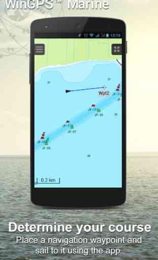
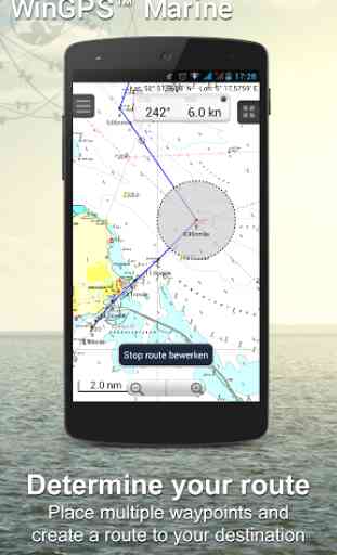
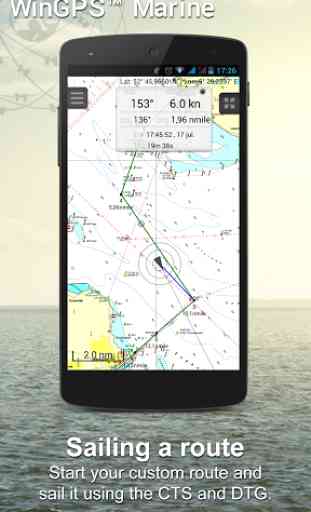
• Very user friendly way to create and edit waypoint and routes.
• Easy management of tracks, charts, routes and waypoints.
• Worldwide wind, air pressure, and rainfall prediction.
• Independent navigation system thanks to the internal GPS of your tablet or smartphone.
• Connect AIS and GPS wirelessly using a WIFI or Bluetooth connection.
• Avoid collisions with the velocity vectors of AIS vessels around you.
• The man-overboard button marks the position of the lost crew member and helps you find it.
IN-APP PURCHASEAfter purchasing WinGPS™ Marine you unlock the full features of the app. Check out the various possibilities on www.wingpsmarine.com.
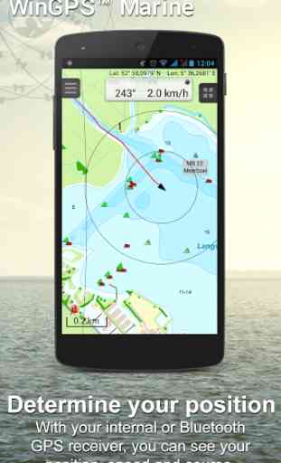
When first installing the app you will get the Lite version of WinGPS™ Marine. This version is limited functionality. With your GPS (internal or bluetooth) you get the SOG and COG and you will see the current position on your screen.
WinGPS™ Marine is the navigation app that allows true marine navigation on your Android device. In this app you can use the digital nautical charts for route planning with GPS via WIFI or bluetooth. You can also get data from AIS, GRIB meteo and record the tracks you have sailed. Use the built-in "timebar" to see the developments of the wind, rain, air pressure and AIS plotted on the screen.
The WinGPS™ Marine Plus upgrade provides you all the best of the Marine Apps. This advanced navigation app helps you plan routes under every condition. You can connect your board system using a wireless connection and use all this data to your advantage. The worldwide tidal & current predictions can be displayed in the data plotter, and on your chart screen.
CHART COVERAGE & INSTALLING CHARTSWhen starting WinGPS™ Marine you will automatically use the free charts of OpenStreetMap. You can also download the free world chart via the chart manager.
For safe navigation you can best use digital water charts which Stentec offers you in the Google Play ™ store or in the online shop on www.stentec.com. When purchasing a chart you get a license code which you can activate on 2 separate machines (with a third backup activation). This enables you to use the charts on your Android device as well as on your laptop/PC.
If you purchased charts using Google Play™, you need to connect them with your account to use them in WinGPS™ Marine. You can do this 2 hours after purchase. If you purchased the charts via www.stentec.com, this will go automatically.
If you login in WinGPS™ Marine, you can select your DKW chart licenses in the chart manager to download and update for use in the app. The charts are immediately ready for use!Examples of DKW Charts are: Stentec’s DKW charts, UKHO, BSH, Imray, Delius Klasing and the DKW 1800 series with weekly BaZ update service.
On your PC you can download the free BSB charts of for example NOAA. After installation with the DKW Manager, you can copy these charts to your tablet. The easiest way to do this is with a USB cable.Examples of NOAA/BSB charts are: United States, Brazil, New Zealand, and all charts you create with DKW Builder (scanned charts).
USER FEEDBACKWe are very interested in your experiences with this app and your suggestions so that we can use it to improve this app. If you got any suggestions, please send an e-mail to [email protected].
Category : Travel & Local
Reviews (29)
Their website can be difficult and clumsy to work with but their navigation software is extraordinarily good for our purpose - following the inland waters of Europe.
Doesn't seem to do anything I need, no AIS connection over Wi-fi, can't import waypoint GPX file, no CPA / TCPA calculations.
Amazing and very successful what you do for this app thank you.
Its designed for Dutch sailors. Nothing for Americans yet.
Thanks for this app
I'm unable to update my charts also I paid for upgrade pack but I didn't received any code to enter neither I'm able to update my charts
A waste of time. A trick to get you to buy charts.
You have to create an account to get this thing to work and I'm not about to do that. Also requires access to everything on your phone. There are much better boating apps than this one.
Trash app. Feels like compiling Linux programs, very user NOT FRIENDLY setup. Not to mention that is a PAY ONLY app, not free at all.
Absolutely no after-sales support from Stentec. Upgraded to the Plus version, failed to receive any upgrade code so stuck with the light version. Several polite emails sent to the developers, but no response. So wasted £72.71. Fraud.
I took my Sony 2 smart watch with me in the dinghy (Supernova tri). WinGps Smart watch app sucked the battery empty in less than 1 1/5 hour... did anyone from the development team ever go sailing with the watch app?
Insufficant depth nav. Needed to be good app. Color tint each depth
No any functionality in light version. Do a little bit more features in light version, otherwise I expect same in pro version.
We are now easily use in mid see...
Needs to much information, Uninstaller.
Download is free but everyhing next costs 0/10
Very easy to use , has all the things I need ,great fun,
Uploading BSB, I love it. Some euros for a good product is not an issue !!
thank you
Where can I get western pacific islands maps
I need maps of areas in south east asia, I am in Maldives and could use a map of the place.
There are NO charts for North America. It is all Europe based.
Unable to get a response from support, paid 129 Euros for chart that will not download. GPS position is displayed abt 15 kilometres east of actual position. Website reverts to Dutch home page. An inadequately supported package
High Definition
Maps loaded very inconsistent on my Galaxy Tab 4, not something that I would feel comfortable using for navigation, decided to uninstall the app.
Should say that in the description
Love it
Sorry
need to buy a chart before doing anything. search at website didn't work.. blank screen and reload didn't work. should have a bare minimum chart so we can see how it works as it seems to have much potential. Update: developer responded quickly with charts to download and options, which I did try unsuccessfully. My point to them is to include one chart, I don't care if it's eastside Kazakhstan but then we can proceed and evaluate whether to proceed.