World atlas & world map MxGeo
Designed for smartphones and tablets.
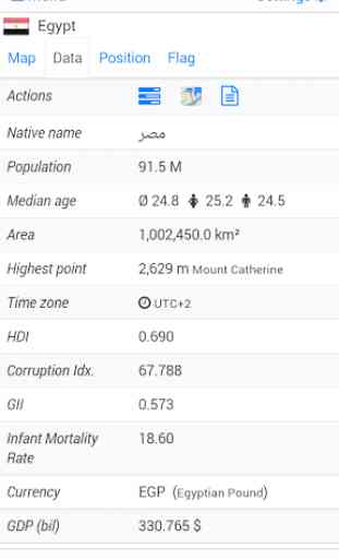
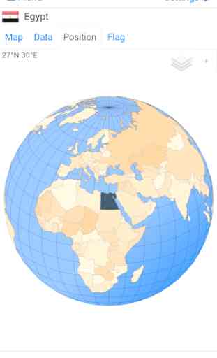
• Flags, position maps and basic data for 240 countries of the world
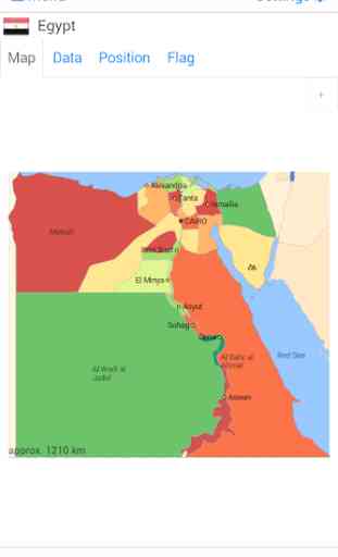
• Detailed political maps and comprehensive data of all African countries
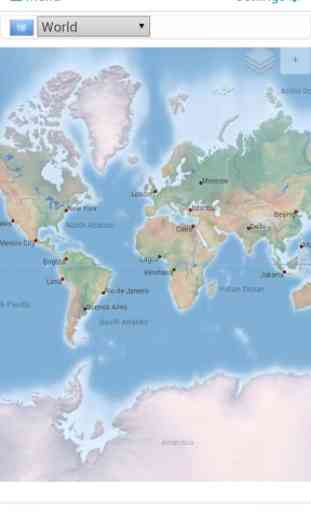
• Interactive political world and continent maps
• Shaded relief layer for world and continent maps
• Geography quiz challenge for playful learning
• Country comparison and favorites
• Configurable world clock with time zone display
• World-explorer: the smallest, largest, wealthiest, ... countries
• All data and maps included, no online connection required
• No advertising or In App Purchases
• No permissions required
Explore the world by political world and continent maps offline maps. Learn where each country in the world is located. View its position highlighted on a digital globe. Create your favorite color theme or choose from different color schemes for map display.
Do you know the flag of Zambia? Yes? Perfect. Do you also know in which country Mount Kilimanjaro is located? “World atlas & world map MxGeo Free” Quiz helps you acquire a geographic literacy in a playful manner. Choose from six geo guessing games:
• Test your knowledge about the capitals of Africa
• Do you know the ISO countries codes?
• Recognize the proper country flag based on the outline map
• Do you know the top-level domains of each country?
• Guess the highlighted country on the virtual globe
• Do you know the mountains of Africa?
Geo learning app and educational game which is fun for everyone whether children, adults, seniors or teachers. Get ready for your next stay abroad while enjoying this great world almanac including time zones and statistical data, such as population growth, unemployment rate, average age, gross domestic product (GDP) by sector and other key figures. Or prepare for your next geography lesson with this genius digital world map. If not traveling our world atlas lets you explore the world just only virtually.
Free version includes comprehensive data and maps for all African countries. Get “World atlas & world map MxGeo Pro” with detailed data and maps including regional units and capitals for 240 countries and territories of the world: Europe, Asia, North America, Africa, Oceania and South America.
Version history:Version 1.1:
- initial version with world map, country maps, country data and flags
- capitals quiz: test your knowledge of the main cities in the world
- country flag quiz: recognize the right country flag based on the outline map
Version 1.4:
- world-explorer: explore the smallest, largest, wealthiest and most populated countries
Version 1.5:
- country comparison: quick comparison of countries and territories
- favorites: shortcut your favorite countries
- new key figure "average age" in World-Explorer
Version 1.7:
- additional Geography Quiz: guess the highlighted country on the virtual globe
Version 2.0:
- added high resolution flags for all countries
Version 2.3:
- added population growth chart for all countries
- removed permissions, app request zero permissions now
Version 2.6:
- continent maps of Asia, Europe, South and North America and Oceania
- 2 new quiz games: ISO 3166-1 codes and TLD
- enhanced display for timezone info
- world clock Daylight saving time bug fixed
- improved quiz gameplay and map view
- country data: correction and updates
Version 2.8:
- New: World Tag Cloud
- Improved country comparison, with sorting function
- Full-screen mode for Android >4.4
- Additional Geo Quiz: mountains of the world
- New key figure "HDI" in World Explorer
- Corrections and updates of country data and maps
Category : Education
Reviews (25)
The sizes are so wrong, Greenland is the same size as Saudi Arabia and smaller than Algeria, it's so much bigger on the map, and Russia and America are Not That big
I'm just update my pro version but it more lagged than before when I swipe the map and sometimes the world map don't load at all, so I decided to download free version too because I think it not make my phone working hard consider it had small size. But nothing change
The app was good and it was helping me a lot, but now you have spoilt it when it was upgraded. Some of the features spoilt in the app are the quiz side and others. So please fix everything well for us. And at first, i rated the app with 5 stars, but when you spoilt it, i reduced the stars.
"The best of world atlases app with splendid classical features; it gave every indication of continents, capitals, even pop quiz to open our minds etc."
This map is missing the names of some of the Islands in the West Indies, e.g. Trinidad and Tobago. It has a good intent but still needs some work.
This app contains wrong maps. Regions of Gilgit-Baltistan has shown as the part of Pakistan and region of Aksai chin has shown as the part of China. But both the regions are the part of Bharat. Exept this there are many regions with wrong maps. Please make corrections and update this app.
Uninstalling your app. It is showing parts of india (kashmir) as pakistan and china. Though the areas are disputed, you cannot change internationally accepted political maps on yor on.
Even Wikipedia has a better map of India...at least they're displaying the disputed area....This useless app doesn't even clarifies disputed areas...and give aways territories to neighbouring countries, all on its own...I will write a letter to the Ministry of External Affairs, Government of India about this, they'll do the same what they did to a TV Channel like Al-Jazeera...I hope, they correct it asap!
You can't see any maps unless you buy the pro version. And you can't figure out if the pro version will be worth the money because you can't see any maps.
Worst phone atlas ever downloaded. It is so bad then also it asks for a pro version. Worst map ever
Very good useful statistics.A good and worthy work. Comments quiz does not allow for yes answers.
Very very good, has no problems at all. There is just one wrong thing: Bahrain is missing! Please fix this.
Not a good but a politicalized app. It shows Limpiyadhura, Lipulek, Kalapani, Mt. Kanchanjunga, etc. in India which are the parts of sovereign country Nepal.
A good app. But there is no photo Pakistan. I have already shared a photo of Pakistani landscape. Please improve this.
This is a very bad and worst map in all over world fully wrong map please change it by developer or any person don't install this app disgusting😠😠😠
the app is magnificent ,but lack the availability of the rest data
Thank you to locate us how the world is, this app is so helpful to everyone mostly to the travellers. I grateful about this service you gave us 🙏
Good basic data for all countries, more data in Pro version
This app so so amazing! 😍 As a PNG🇵🇬 SS student, I'm real blessed with it.😁.. Thanks for creating this App.
One of the best apps for maps and Country information
3 stars for the info 2 stars for no ads and no permissions. Thanks.
It is wonderful wonderful and wonderful app. Please add bangla language.
Very good atlas app and too much beneficial.
Thanks for getting back to me..I will attempt to clarify.. 1. The uk is not nor has it ever been a single sovereign nation. It is a political union between the sovereign nations of Scotland and england. It was signed in 1707. It setup a joint currency amongst other things like tax. 2. Hence the comparison with the EU, which is a treaty of political too. 3. Calling the EU a sovereign nation is insulting, just as it is calling the uk a nation. Please amend. Thank you.
Dear developer(s), your app is a welcome addition. Thanks for sharing it. I have some suggestions that I hope you would agree with and introduce in an update, viz: 1) Some soft, soothing background music to accompany us as we explore, 2) Indication BY NAME & MEASUREMENT of the most prominent physical features, i.e, the tallest peaks of mountain ranges, the deepest points of the oceans, the longest rivers, etc. Good luck and thanks.