Zdobądź Tatry SK - przewodnik GPS po T. Słowackich
- 12 ready to use the routes of trips to popular destinations also available in winter (more routes for the summer in preparation)
- set a route in terms of time, the landscape, the region of Slovak Tatras
- You can also organize their own route based on more than 220 episodes of Slovak Tatras trails
- facilitate intuitive graphic interface planning
- you'll see information about the length, the transition and the total approaches the planned route
- Navigate the route in the map mode and the list mode points
- conduction browse information about more than 570 places on the trails
- passing points may be indicated by a sound or vibration
- herring dynamic route statistics - road, time, angle of approach
- react to the warnings about leaving the route and the time remaining until dusk
- Check the current weather forecast of the National Institute of Meteorology
- checkups through Facebook
-------------------------------------------------- ----------
detailed Description
Tours
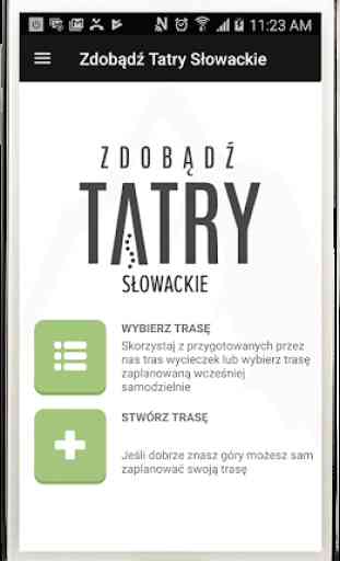
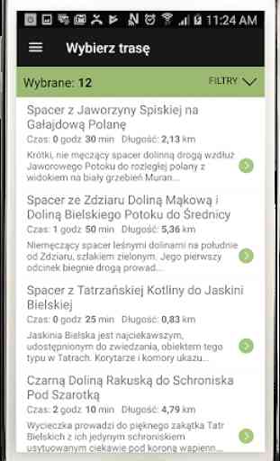
routes ready
The application includes a route developed by the publisher of 12 tours leading to the most popular and interesting places in the Slovakian Tatras - also available in winter. Their selection makes it easy to search and filter on a set of simple: time tours, the prevailing character of the landscape or the area of the Tatra Mountains.
your own route
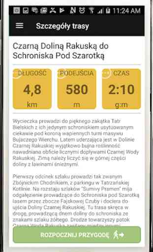
The user creates a route independently of their trips, using the intuitive graphical interface - scheme trails. Developed independently trip has given a user name, and information about the route length, total time of transition approaches and provides an application.
navigation
Read by the user's GPS position is not only visible on the map with the marked trail - but also on a clear line diagram showing more points on the trail. It gives updated information about the route traveled, time remaining and the time remaining until dusk and the angle of the section of the route and the distance to the nearest intersection of routes.
Guide
The application presents concise information about conduction passing point, signaled sound and vibration. These are descriptions of intersecting routes, geographical and historical facts and anecdotes sometimes. Complementing the trail guide is a brief introduction in the Tatra climates: Krywaniu, Krywaniu and Tatra National Park - TANAP.
Security
Concerned about the safety of the user application warns about descending from the trail route, transmit weather data for the next hour, and also provides emergency calls to the Mountain Rescue Service - HZS with instructions in an emergency procedure in the Tatra Mountains. It is to guide the appropriate complement to the safety rules in the mountains Tatra developed by rescuers.
maps
The application uses the Internet community created by the OpenStreetMap maps and map content is available on a permanent basis in the phone memory. This map covers the area of the Tatra National Park and the surrounding area of Zakopane and the Tatra Bukovina. As an option, you can take advantage of requiring Internet access OpenCycleMap map - with contour lines.
Facebook
The application enables you to share your experiences with the Tatra routes with friends and friends of facebook. This requires logging in to your account earlier on Facebook.
Internet
Using the navigation tourist guide and does not require access to the Internet. Only use the optional OpenCycleMap maps, updated weather forecasts and check in on Facebook requires mobile network signal, the availability of goods on the peaks and ridges can be - depending on the operator, worse in the Tatra valleys.
WARNING! Continuous use of the GPS function in the background can significantly shorten the battery life of the phone.
- set a route in terms of time, the landscape, the region of Slovak Tatras
- You can also organize their own route based on more than 220 episodes of Slovak Tatras trails
- facilitate intuitive graphic interface planning
- you'll see information about the length, the transition and the total approaches the planned route
- Navigate the route in the map mode and the list mode points
- conduction browse information about more than 570 places on the trails
- passing points may be indicated by a sound or vibration
- herring dynamic route statistics - road, time, angle of approach
- react to the warnings about leaving the route and the time remaining until dusk
- Check the current weather forecast of the National Institute of Meteorology
- checkups through Facebook
-------------------------------------------------- ----------
detailed Description
Tours
routes ready
The application includes a route developed by the publisher of 12 tours leading to the most popular and interesting places in the Slovakian Tatras - also available in winter. Their selection makes it easy to search and filter on a set of simple: time tours, the prevailing character of the landscape or the area of the Tatra Mountains.
your own route
The user creates a route independently of their trips, using the intuitive graphical interface - scheme trails. Developed independently trip has given a user name, and information about the route length, total time of transition approaches and provides an application.
navigation
Read by the user's GPS position is not only visible on the map with the marked trail - but also on a clear line diagram showing more points on the trail. It gives updated information about the route traveled, time remaining and the time remaining until dusk and the angle of the section of the route and the distance to the nearest intersection of routes.
Guide
The application presents concise information about conduction passing point, signaled sound and vibration. These are descriptions of intersecting routes, geographical and historical facts and anecdotes sometimes. Complementing the trail guide is a brief introduction in the Tatra climates: Krywaniu, Krywaniu and Tatra National Park - TANAP.
Security
Concerned about the safety of the user application warns about descending from the trail route, transmit weather data for the next hour, and also provides emergency calls to the Mountain Rescue Service - HZS with instructions in an emergency procedure in the Tatra Mountains. It is to guide the appropriate complement to the safety rules in the mountains Tatra developed by rescuers.
maps
The application uses the Internet community created by the OpenStreetMap maps and map content is available on a permanent basis in the phone memory. This map covers the area of the Tatra National Park and the surrounding area of Zakopane and the Tatra Bukovina. As an option, you can take advantage of requiring Internet access OpenCycleMap map - with contour lines.
The application enables you to share your experiences with the Tatra routes with friends and friends of facebook. This requires logging in to your account earlier on Facebook.
Internet
Using the navigation tourist guide and does not require access to the Internet. Only use the optional OpenCycleMap maps, updated weather forecasts and check in on Facebook requires mobile network signal, the availability of goods on the peaks and ridges can be - depending on the operator, worse in the Tatra valleys.
WARNING! Continuous use of the GPS function in the background can significantly shorten the battery life of the phone.
Category : Travel & Local
Related searches