
Boating Marine & Lakes
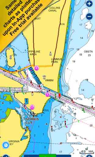
The world’s most popular marine & lakes app! A favorite among cruisers, sailors, fishermen and divers. Find the same detailed charts as on the best GPS plotters. Download the app and upon opening get an automatic 15 day free trial for any location in the world to experience the overwhelming value of Navionics+: the most detailed charts and advanced features. At any time, tap Menu>Shop for mobile chart coverage for anywhere in the world, sonar devices that can be connected to your mobile, as well as GPS plotter cards.
Navionics+ includes:
√ Download of the following chart layers that will reside on your device even after expiration:
-NAUTICAL CHART for all essential cartographic reference detail. The most accurate and thorough set of information based on Hydrographic Office data, Notices to Mariners, new publications, our own surveys, and reports from users. It provides port plans, safety depth contours, marine services info, tides & currents, navigation aids and more.
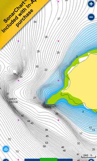
-SONARCHART™ the award-winning 1 ft/ 0,5 m HD bathymetry map that reflects ever-changing conditions. Be part of the community and contribute by uploading your sonar logs to enhance it.
- COMMUNITY EDITS made by users (rocks, wrecks, etc.) and shared for all to benefit.
√ CHART UPDATES: we deliver more than 2,000 updates every day! Take advantage of our updates as frequently as you like.
√ ADVANCED MAP OPTIONS to highlight Shallow Areas and filter Depth Contours. It also includes a Fishing Mode that enables Fishing Range for targeting key fishing areas.
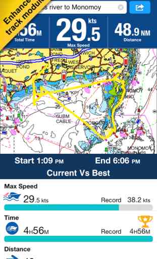
√ NAVIGATION MODULE for advanced route planning with ETA, distance to arrival, heading to WP, fuel consumption and more!
√ DOCK-TO-DOCK AUTOROUTING quickly creates detailed routes even through narrow waterways and channels, based on chart data and navigation aids. POIs are automatically shown nearby your destination.
√ WEATHER & TIDES provides real-time weather data and forecasts. Access daily and hourly forecasts for your favorite locations and get wind, weather buoys, Tides & Currents overlaid on your map. Buoy data is retrieved from NOAA and can include wind speed, gust and direction as well as air pressure, water temperature, wave height and other relevant marine data.
√ TIMELINE where you can see all the photos taken while tracking, POIs and Navionics panoramic images.
Note: Download detailed maps by zooming in or from Menu>Download Map.
Navionics+ is a one year subscription. At expiration you can renew with a discount of up to 50%. If you don’t renew, you can still use the charts you previously downloaded, along with several free features:
TRACK your journey, view speed, distance, start, stop and total time and COG. Save, see stats and playback.
ROUTES: create and edit, based on speed and fuel consumption.
Measure DISTANCE, add MARKERS, get WIND FORECASTS and sun/moon cycles.
MAP OPTIONS: Satellite/Terrain, adjust shorelines to selected Water Level, choose Depth Shading and Easy View (not on Govt. Charts).
SYNC Tracks, Routes & Markers among your mobile devices.
MAGAZINES & GUIDES for location-based articles.
GOVT. CHART in US.
SONARCHART™ LIVE allows you to create new personal 1 ft/0.5 m HD bathymetry maps that display in real time while navigating. Upload your sonar logs to build even better local charts for your area connecting wirelessly to a compatible sounder/plotter
PLOTTER SYNC - Compatible Wi-Fi enabled plotter owners can transfer routes and markers, activate and update their eligible plotter card and upload sonar logs for improved SonarChart™! Plug in your plotter card, open app and go to Menu>Connect a device to begin! Learn more at www.navionics.com/plotter-sync
Updates are available with iOS 8.4 or higher devices.
To enjoy our charts in HD, search our apps for iPad.
Continued use of GPS running in the background can dramatically decrease battery life.
Navionics+ includes:
√ Download of the following chart layers that will reside on your device even after expiration:
-NAUTICAL CHART for all essential cartographic reference detail. The most accurate and thorough set of information based on Hydrographic Office data, Notices to Mariners, new publications, our own surveys, and reports from users. It provides port plans, safety depth contours, marine services info, tides & currents, navigation aids and more.
-SONARCHART™ the award-winning 1 ft/ 0,5 m HD bathymetry map that reflects ever-changing conditions. Be part of the community and contribute by uploading your sonar logs to enhance it.
- COMMUNITY EDITS made by users (rocks, wrecks, etc.) and shared for all to benefit.
√ CHART UPDATES: we deliver more than 2,000 updates every day! Take advantage of our updates as frequently as you like.
√ ADVANCED MAP OPTIONS to highlight Shallow Areas and filter Depth Contours. It also includes a Fishing Mode that enables Fishing Range for targeting key fishing areas.
√ NAVIGATION MODULE for advanced route planning with ETA, distance to arrival, heading to WP, fuel consumption and more!
√ DOCK-TO-DOCK AUTOROUTING quickly creates detailed routes even through narrow waterways and channels, based on chart data and navigation aids. POIs are automatically shown nearby your destination.
√ WEATHER & TIDES provides real-time weather data and forecasts. Access daily and hourly forecasts for your favorite locations and get wind, weather buoys, Tides & Currents overlaid on your map. Buoy data is retrieved from NOAA and can include wind speed, gust and direction as well as air pressure, water temperature, wave height and other relevant marine data.
√ TIMELINE where you can see all the photos taken while tracking, POIs and Navionics panoramic images.
Note: Download detailed maps by zooming in or from Menu>Download Map.
Navionics+ is a one year subscription. At expiration you can renew with a discount of up to 50%. If you don’t renew, you can still use the charts you previously downloaded, along with several free features:
TRACK your journey, view speed, distance, start, stop and total time and COG. Save, see stats and playback.
ROUTES: create and edit, based on speed and fuel consumption.
Measure DISTANCE, add MARKERS, get WIND FORECASTS and sun/moon cycles.
MAP OPTIONS: Satellite/Terrain, adjust shorelines to selected Water Level, choose Depth Shading and Easy View (not on Govt. Charts).
SYNC Tracks, Routes & Markers among your mobile devices.
MAGAZINES & GUIDES for location-based articles.
GOVT. CHART in US.
SONARCHART™ LIVE allows you to create new personal 1 ft/0.5 m HD bathymetry maps that display in real time while navigating. Upload your sonar logs to build even better local charts for your area connecting wirelessly to a compatible sounder/plotter
PLOTTER SYNC - Compatible Wi-Fi enabled plotter owners can transfer routes and markers, activate and update their eligible plotter card and upload sonar logs for improved SonarChart™! Plug in your plotter card, open app and go to Menu>Connect a device to begin! Learn more at www.navionics.com/plotter-sync
Updates are available with iOS 8.4 or higher devices.
To enjoy our charts in HD, search our apps for iPad.
Continued use of GPS running in the background can dramatically decrease battery life.
Category : Navigation
Related searches