Boston T Map - MBTA subway map
The ultimate navigation app for getting around on the Boston T. This official MBTA map and route planner is an essential tool for making journeys simple and stress free. The Boston T app is packed with helpful information and knowledge.
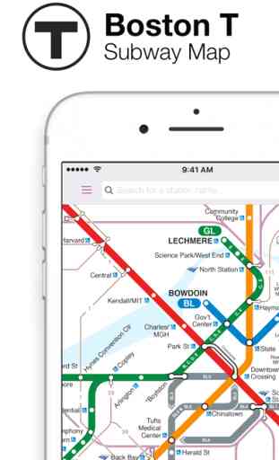
OFFICIAL MBTA MAP
Pan and zoom around an interactive Boston T map and tap on any station including the Commuter Rail. The MBTA map also shows key bus and ferry routes.
USE OFFLINE
The app works offline so you can view the MBTA map and plan routes even without an internet connection.
CHECK TRAIN TIMES
View train times for the Boston T by tapping any station on the MBTA map to see how long you’ll be waiting.
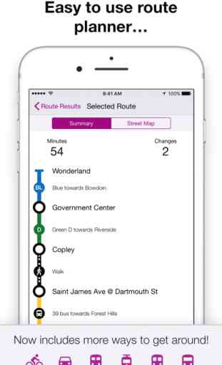
PLAN ROUTES
It’s easy to get around using the helpful Route Planner! Simply tell the app a start and end point to see the best ways to get there.
Get useful information when you plan a route, such as traveling times and changes.
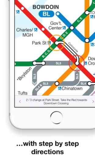
GET DIRECTIONS
Don’t worry about getting lost! Each route comes with step-by-step directions on the MBTA map so you can see every section of your journey.
VISIT NEW PLACES
Head to Boston Common or visit New England Aquarium using The T. You can route to popular points of interest and the app will find you the best route.
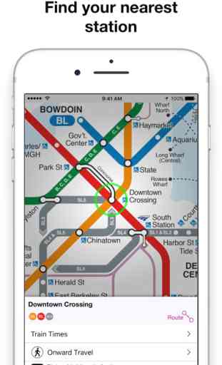
SAVE TIME
Unsure which is the closest Boston T station to you? Wherever you are the app will show your nearby stations and how far away they are.
Mapway is the world’s number one in public transport apps with over 36 million downloads. Visiting New York, London or Paris? Check out all of the free navigation apps by Mapway.
Plan. Route. Relax.
Join us on Facebook or follow us on Twitter by searching Mapway Apps, we would love to hear from you!
OFFICIAL MBTA MAP
Pan and zoom around an interactive Boston T map and tap on any station including the Commuter Rail. The MBTA map also shows key bus and ferry routes.
USE OFFLINE
The app works offline so you can view the MBTA map and plan routes even without an internet connection.
CHECK TRAIN TIMES
View train times for the Boston T by tapping any station on the MBTA map to see how long you’ll be waiting.
PLAN ROUTES
It’s easy to get around using the helpful Route Planner! Simply tell the app a start and end point to see the best ways to get there.
Get useful information when you plan a route, such as traveling times and changes.
GET DIRECTIONS
Don’t worry about getting lost! Each route comes with step-by-step directions on the MBTA map so you can see every section of your journey.
VISIT NEW PLACES
Head to Boston Common or visit New England Aquarium using The T. You can route to popular points of interest and the app will find you the best route.
SAVE TIME
Unsure which is the closest Boston T station to you? Wherever you are the app will show your nearby stations and how far away they are.
Mapway is the world’s number one in public transport apps with over 36 million downloads. Visiting New York, London or Paris? Check out all of the free navigation apps by Mapway.
Plan. Route. Relax.
Join us on Facebook or follow us on Twitter by searching Mapway Apps, we would love to hear from you!
Category : Navigation
Related searches