Flight Ops
Flight Ops is an app specially designed for pilots, flight dispatchers and anyone involved in Flight Operations.
Main functions:
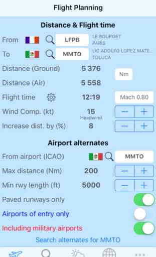
Distance and flight time computation, based on the following parameters:
-Mach number
-Wind component
-ISA deviation
-Distance factor to compensate great circle distance
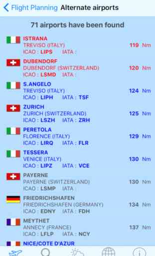
Alternate airports search, based on the following parameters:
-Distance from destination
-Minimum runway length
-Paved runways or not
-Airports of entry or not
-Including military airports or not
They will be automatically sorted by their distance from selected destination airport
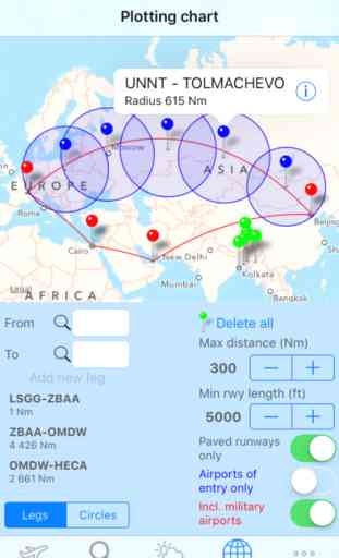
Map where you can plot:
-Great circle routes between airports
-ETP circles based on a specific radius
-By a long push on the map you can display all airports around, making fast and easy the selection of ETP airports
As for alternates search, this selection is based on same parameters (distance, runway length, paved runways or not, airports of entry or not, including military airports or not)
Airports database:
You can search in the database and retrieve any airport(s) based on the following parameters:
-ICAO code
-IATA code
-Airport name
-City name
Weather and airports informations:
-You can build your own favorite airports list to check weather status at a glance
-For any airport, you can get the latest METAR and/or TAF (if available)
-Based on current wind speed and direction, Flight Ops will display all runways with corresponding crosswind and headwind components
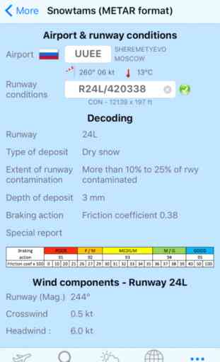
Snowtams (METAR format):
Just make a copy paste of any snowtam or simply use the wheel. You will then get:
-Full decoding
-Crosswind and headwind components based on the related runway.
Main functions:
Distance and flight time computation, based on the following parameters:
-Mach number
-Wind component
-ISA deviation
-Distance factor to compensate great circle distance
Alternate airports search, based on the following parameters:
-Distance from destination
-Minimum runway length
-Paved runways or not
-Airports of entry or not
-Including military airports or not
They will be automatically sorted by their distance from selected destination airport
Map where you can plot:
-Great circle routes between airports
-ETP circles based on a specific radius
-By a long push on the map you can display all airports around, making fast and easy the selection of ETP airports
As for alternates search, this selection is based on same parameters (distance, runway length, paved runways or not, airports of entry or not, including military airports or not)
Airports database:
You can search in the database and retrieve any airport(s) based on the following parameters:
-ICAO code
-IATA code
-Airport name
-City name
Weather and airports informations:
-You can build your own favorite airports list to check weather status at a glance
-For any airport, you can get the latest METAR and/or TAF (if available)
-Based on current wind speed and direction, Flight Ops will display all runways with corresponding crosswind and headwind components
Snowtams (METAR format):
Just make a copy paste of any snowtam or simply use the wheel. You will then get:
-Full decoding
-Crosswind and headwind components based on the related runway.
Category : Navigation
Related searches