Flyover Country
Track your flight with GPS - discover information about the world below and clouds above with offline maps and POI. Worldwide.
**GPS functionality is only possible from the window seat and GPS reception quality varies by device/conditions**
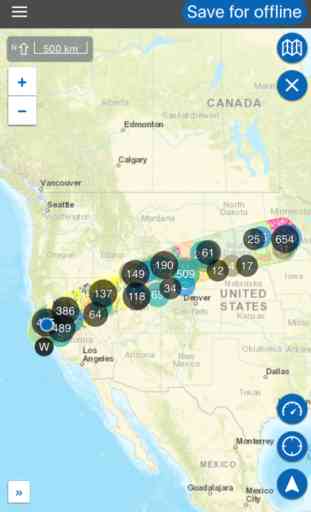
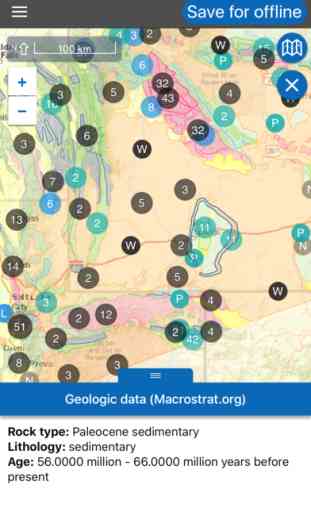
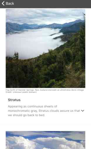
Learn about the world along the path of your flight, hike, or road trip with GPS tracking. Offline geologic maps and interactive points of interest reveal the locations of fossils, core samples, and georeferenced Wikipedia articles visible from your airplane window seat, road trip, or hiking trail vista.
Follow Flyover Country for updates and photos from the sky!
https://www.facebook.com/flyovercountryapp/
https://twitter.com/flyovergeo/
https://www.instagram.com/flyovergeo/
http://fc.umn.edu/
Submit issues, suggestions, and comments via Google Forms http://goo.gl/forms/Yhw9AvMcbTOHTZCf1
Flyover Country is a National Science Foundation funded offline mobile app for geoscience outreach and data discovery. The app exposes interactive geologic maps from Macrostrat.org, fossil localities from Neotomadb.org and Paleobiodb.org, Wikipedia articles, offline base maps, and the user’s current GPS determined location, altitude, speed, and heading. The app analyzes a given flight path and caches relevant map data and points of interest (POI), and displays these data during the flight, without in flight wifi. By downloading only the data relevant to a particular flightpath, cache sizes remain reasonable, allowing for a robust experience without an internet connection.
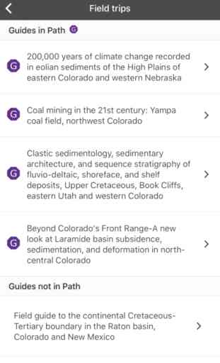
Flyover Country is not limited to the window seat of airplanes. It is also ideal for road trips, hiking, and other outdoor activities such as field trips and geologic field work.
How to use FC:
-Tap two or more points on the map to specify your path, then click 'Load path' in the top right corner to view the data associated with the path. Select 'Save for offline' to store the data and associated articles on your device for offline use. Access saved paths from the 'Saved' menu.
-While moving, press the arrow in the lower right-hand corner of the screen to enable navigation mode. This will lock the screen to your position and orient the map to your direction of travel. Press this button again to exit this mode if you need to pan around the map.
-You may also select your 'Trip mode' from the side menu. the 'plane' provides a wide strip of data while 'car/foot' provides a narrower but more detailed geologic map with detailed unit descriptions and metadata.
Please report any bugs to Shane at Loeff081 at d.umn.edu
Warning: Continued use of GPS running in the background can dramatically decrease battery life. Please turn off navigation mode when not in use.
**GPS functionality is only possible from the window seat and GPS reception quality varies by device/conditions**
Learn about the world along the path of your flight, hike, or road trip with GPS tracking. Offline geologic maps and interactive points of interest reveal the locations of fossils, core samples, and georeferenced Wikipedia articles visible from your airplane window seat, road trip, or hiking trail vista.
Follow Flyover Country for updates and photos from the sky!
https://www.facebook.com/flyovercountryapp/
https://twitter.com/flyovergeo/
https://www.instagram.com/flyovergeo/
http://fc.umn.edu/
Submit issues, suggestions, and comments via Google Forms http://goo.gl/forms/Yhw9AvMcbTOHTZCf1
Flyover Country is a National Science Foundation funded offline mobile app for geoscience outreach and data discovery. The app exposes interactive geologic maps from Macrostrat.org, fossil localities from Neotomadb.org and Paleobiodb.org, Wikipedia articles, offline base maps, and the user’s current GPS determined location, altitude, speed, and heading. The app analyzes a given flight path and caches relevant map data and points of interest (POI), and displays these data during the flight, without in flight wifi. By downloading only the data relevant to a particular flightpath, cache sizes remain reasonable, allowing for a robust experience without an internet connection.
Flyover Country is not limited to the window seat of airplanes. It is also ideal for road trips, hiking, and other outdoor activities such as field trips and geologic field work.
How to use FC:
-Tap two or more points on the map to specify your path, then click 'Load path' in the top right corner to view the data associated with the path. Select 'Save for offline' to store the data and associated articles on your device for offline use. Access saved paths from the 'Saved' menu.
-While moving, press the arrow in the lower right-hand corner of the screen to enable navigation mode. This will lock the screen to your position and orient the map to your direction of travel. Press this button again to exit this mode if you need to pan around the map.
-You may also select your 'Trip mode' from the side menu. the 'plane' provides a wide strip of data while 'car/foot' provides a narrower but more detailed geologic map with detailed unit descriptions and metadata.
Please report any bugs to Shane at Loeff081 at d.umn.edu
Warning: Continued use of GPS running in the background can dramatically decrease battery life. Please turn off navigation mode when not in use.
Category : Travel
Related searches