MapMyPlaces
MapMyPlaces is a great tool for plotting multiple locations on a map.
Use this app to plan or record a multi-stop tour or journey.
Add a location by simply touching the map, entering a search term in the search bar, selecting a location from your contacts or by selecting a photo from your photo albums and camera roll.
Interested in knowing where you have been but do not want to waste battery power running your device’s GPS? Just take a photo at key points in your journey and MapMyPlaces will plot on a map the photos you select from your camera roll (or any photo on your device including your iCloud photo stream), and generate a route with addresses, distances and directions from those photos. Then view a slideshow of the photos in your route by simply double tapping any photo attached to a location.
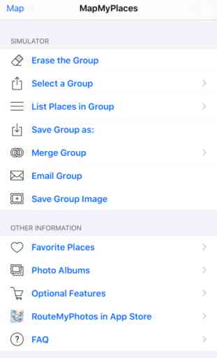
Optionally, you can add the Save Data, Photos & Email feature which enables you to save save groups of locations, plot on a map any photos on your device and input/export this data in GPX and KML format via email.
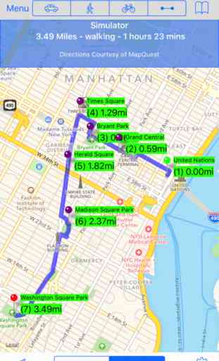
A Second option, is to add Routing, which will calculate and display driving, walking, cycling or point-to-point directions between up to 26 locations.
Features:
▪ Add any number of locations on a map.
▪ Add locations by touching the map, entering an address or search term in the Search Bar, by selecting a contact or by selecting a photo from your camera roll.
▪ Locations added from your camera roll will automatically have their addresses looked up and displayed.
▪ Create and view a slideshow of photos you select from your camera roll.
▪ Standard, satellite, and hybrid maps can be displayed.
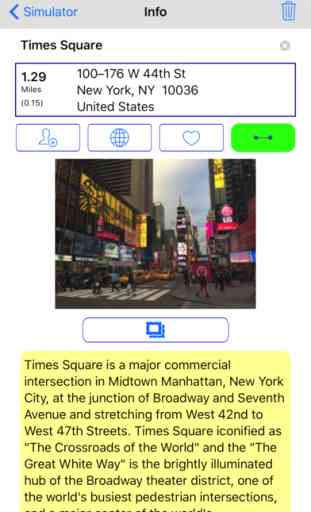
▪ Individual Locations can be passed to and opened in Apple Maps or Google Maps (if installed).
Optional Features:
Save Data, Photos & Email (Optional)
▪ Preserves your privacy by storing your data on your device, not on a website you have to log into to use.
▪ Create a group of locations once, then save them so that you don’t have to recreate them again the future.
▪ Plot locations and create a route using any photo with geolocation data on your device or in iCloud.
▪ Create a slideshow from any photo on your device (by double tapping the photo attached to a location), while also displaying the photo’s location on a map..
▪ For locations you will use repeatedly, save it as a favorite. The addresses of these photos will be automatically generated.
▪ Location address information can be added to your Contacts Address book.
▪ The order of locations can be modified or reversed.
▪ Import and Export location and route data in GPX and KML format..
▪ Emailed groups have a image of your group, a text description of your group, and both GPX and KML attachments that can be loaded onto GPS devices and various websites.
▪ Sync routes among your devices and the devices of your friends and associates by emailing the route to them.
▪ An unlimited number of groups can be saved and viewed even when your device is not connected to the internet.
Routing (Optional)
▪ Create walking, cycling or driving routes of up to 26 locations while connected to the internet.
▪ Create point-to-point routes with an unlimited number of locations even when your device is not connected to the internet.
▪ Preserves your privacy by storing your data on your device, not on a website you have to log into to use.
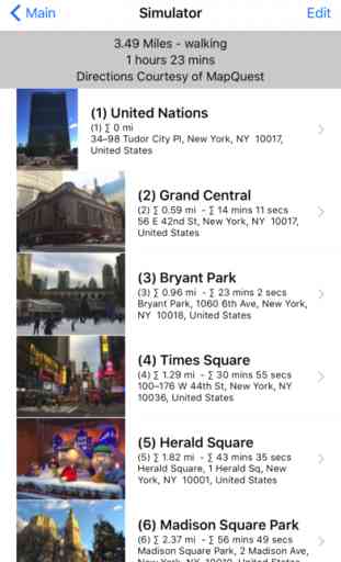
▪ Both visual and written directions with distance and time estimates are created for a route.
▪ Distances are measured in miles or kilometers.
▪ The distance to a pin location from your current location can be displayed.
▪ A scale of miles/kilometers is displayed at the top of your map.
Use this app to plan or record a multi-stop tour or journey.
Add a location by simply touching the map, entering a search term in the search bar, selecting a location from your contacts or by selecting a photo from your photo albums and camera roll.
Interested in knowing where you have been but do not want to waste battery power running your device’s GPS? Just take a photo at key points in your journey and MapMyPlaces will plot on a map the photos you select from your camera roll (or any photo on your device including your iCloud photo stream), and generate a route with addresses, distances and directions from those photos. Then view a slideshow of the photos in your route by simply double tapping any photo attached to a location.
Optionally, you can add the Save Data, Photos & Email feature which enables you to save save groups of locations, plot on a map any photos on your device and input/export this data in GPX and KML format via email.
A Second option, is to add Routing, which will calculate and display driving, walking, cycling or point-to-point directions between up to 26 locations.
Features:
▪ Add any number of locations on a map.
▪ Add locations by touching the map, entering an address or search term in the Search Bar, by selecting a contact or by selecting a photo from your camera roll.
▪ Locations added from your camera roll will automatically have their addresses looked up and displayed.
▪ Create and view a slideshow of photos you select from your camera roll.
▪ Standard, satellite, and hybrid maps can be displayed.
▪ Individual Locations can be passed to and opened in Apple Maps or Google Maps (if installed).
Optional Features:
Save Data, Photos & Email (Optional)
▪ Preserves your privacy by storing your data on your device, not on a website you have to log into to use.
▪ Create a group of locations once, then save them so that you don’t have to recreate them again the future.
▪ Plot locations and create a route using any photo with geolocation data on your device or in iCloud.
▪ Create a slideshow from any photo on your device (by double tapping the photo attached to a location), while also displaying the photo’s location on a map..
▪ For locations you will use repeatedly, save it as a favorite. The addresses of these photos will be automatically generated.
▪ Location address information can be added to your Contacts Address book.
▪ The order of locations can be modified or reversed.
▪ Import and Export location and route data in GPX and KML format..
▪ Emailed groups have a image of your group, a text description of your group, and both GPX and KML attachments that can be loaded onto GPS devices and various websites.
▪ Sync routes among your devices and the devices of your friends and associates by emailing the route to them.
▪ An unlimited number of groups can be saved and viewed even when your device is not connected to the internet.
Routing (Optional)
▪ Create walking, cycling or driving routes of up to 26 locations while connected to the internet.
▪ Create point-to-point routes with an unlimited number of locations even when your device is not connected to the internet.
▪ Preserves your privacy by storing your data on your device, not on a website you have to log into to use.
▪ Both visual and written directions with distance and time estimates are created for a route.
▪ Distances are measured in miles or kilometers.
▪ The distance to a pin location from your current location can be displayed.
▪ A scale of miles/kilometers is displayed at the top of your map.
Category : Navigation
Related searches