National Parks Pocket Maps
Be prepared! Plan your next trip to one of the great national parks. Download maps and guides before you venture into the WiFi free wilderness.
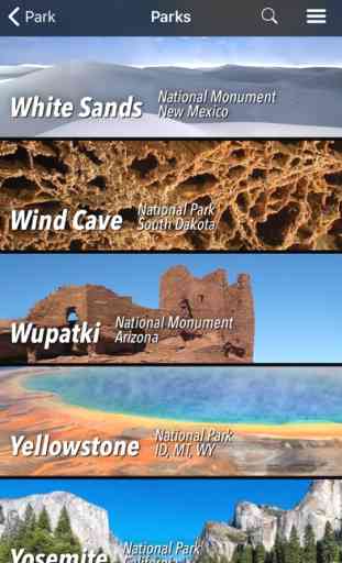
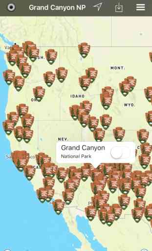
This pocket maps app comes with more than 270 neatly folded national park maps, national monument maps and maps of other great destinations
* download maps, park brochures and newspapers. These downloads are ready when you are offline and off the grid in the great outdoors.
* download arbitrary map sections as offline packs
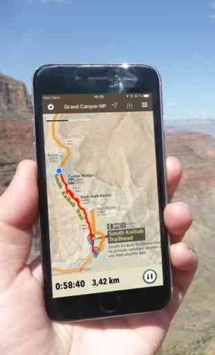
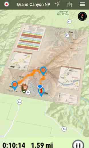
* GPS and GPX support: record your hikes, import GPX routes, tracks and waypoints
* detailed national park information: alerts, news, visitor centers, campgrounds, driving directions, weather
* open your favourite maps app to get a route to the selected park
* current weather conditions, easy access to multi day forecasts, sunrise and sunset times
* photo galleries, panorama views
* push notifications for park alerts, park news, weather warnings
So download maps and guides for:
Acadia
Arches
Badlands
Big Bend
Biscayne
Black Canyon of the Gunnison
Bryce Canyon
Canyonlands
Capitol Reef
Carlsbad Caverns
Channel Islands
Congaree,
Crater Lake
Death Valley
Denali
Dry Tortugas
Everglades
Gates of the Arctic
Glacier
Glacier Bay
Grand Canyon
Grand Teton
Great Basin
Great Smoky Mountains
Guadalupe Mountains
Hot Springs
Isle Royale
Joshua Tree
Katmai
Kenai Fjords
Kings Canyon
Lake Clark
Lassen Volcanic
Mammoth Cave
Mesa Verde
Mount Rainier
National Mall and Memorial Parks
North Cascades
Olympic
Petrified Forest
Pinnacles
Redwood
Rocky Mountain
Saguaro
Sequoia
Shenandoah
Theodore Roosevelt
Virgin Islands
Wind Cave
Yellowstone
Yosemite
Zion
There are lots of maps and brochures for national monuments, national preserves, national recreation areas, ..., like
Alagnak, Aniakchat, Antietam, Assateague Island, Aztec Ruins, Bandelier, Bering Land Bridge, Biscayne, Blue Ridge, Cabrillo, Canyon de Chelly, Cape Krusenstern, Capulin Volcano, Cedar Breaks, Chaco Culture, Chiricahua, Coronado, Curecanti, César E. Chávez, Devils Postpile, Dinosaur, El Malpais, El Morro, Florissant Fossil Beds, Fort Bowie, Fort Point, Gila Cliff Dwellings, Glen Canyon, Golden Gate, Golden Spike, Great Sand Dunes, Indiana Dunes, Lake Mead, Lava Beds, Mammoth Cave, Manzanar, Mojave, Montezuma Castle, Muir Woods, Natural Bridges, Navajo, Organ Pipe Cactus, Parashant, Pecos, Petroglyph, Point Reyes, Rainbow Bridge, Rosie the Riveter WWII Home Front, Salinas Pueblo Missions, San Antonio Missions, San Francisco Maritime, Santa Monica Mountains, Shenandoah, Sitka, Sunset Crater Volcano, Tuzigoot, Valles Caldera, Walnut Canyon, Whiskeytown, White Sands, Wupatki
and many more!
* Subscribe and get full access to all maps, brochures, offline packs and future map updates. The trial plan lets you download all maps and brochures of one selected park and you can create one active offline pack.
* Downloaded maps and brochures can still be used after your subscription expired.
* FULL ACCESS is available for $6.99/year or $1.99/two months. You can subscribe and pay through your iTunes account. Account will be charged for renewal within 24-hours prior to the end of the current period, and identify the cost of the renewal. Your subscription will automatically renew unless cancelled at least 24 hours before the end of the current period. Auto-renew can be turned off anytime by going to your Account Settings in iTunes after purchase.
* Continued use of GPS running in the background can dramatically decrease battery life.
---
LEGAL
Terms of Use: https://www.icoat.de/pocketmaps/terms
Privacy Policy: https://www.icoat.de/pocketmaps/privacy
This pocket maps app comes with more than 270 neatly folded national park maps, national monument maps and maps of other great destinations
* download maps, park brochures and newspapers. These downloads are ready when you are offline and off the grid in the great outdoors.
* download arbitrary map sections as offline packs
* GPS and GPX support: record your hikes, import GPX routes, tracks and waypoints
* detailed national park information: alerts, news, visitor centers, campgrounds, driving directions, weather
* open your favourite maps app to get a route to the selected park
* current weather conditions, easy access to multi day forecasts, sunrise and sunset times
* photo galleries, panorama views
* push notifications for park alerts, park news, weather warnings
So download maps and guides for:
Acadia
Arches
Badlands
Big Bend
Biscayne
Black Canyon of the Gunnison
Bryce Canyon
Canyonlands
Capitol Reef
Carlsbad Caverns
Channel Islands
Congaree,
Crater Lake
Death Valley
Denali
Dry Tortugas
Everglades
Gates of the Arctic
Glacier
Glacier Bay
Grand Canyon
Grand Teton
Great Basin
Great Smoky Mountains
Guadalupe Mountains
Hot Springs
Isle Royale
Joshua Tree
Katmai
Kenai Fjords
Kings Canyon
Lake Clark
Lassen Volcanic
Mammoth Cave
Mesa Verde
Mount Rainier
National Mall and Memorial Parks
North Cascades
Olympic
Petrified Forest
Pinnacles
Redwood
Rocky Mountain
Saguaro
Sequoia
Shenandoah
Theodore Roosevelt
Virgin Islands
Wind Cave
Yellowstone
Yosemite
Zion
There are lots of maps and brochures for national monuments, national preserves, national recreation areas, ..., like
Alagnak, Aniakchat, Antietam, Assateague Island, Aztec Ruins, Bandelier, Bering Land Bridge, Biscayne, Blue Ridge, Cabrillo, Canyon de Chelly, Cape Krusenstern, Capulin Volcano, Cedar Breaks, Chaco Culture, Chiricahua, Coronado, Curecanti, César E. Chávez, Devils Postpile, Dinosaur, El Malpais, El Morro, Florissant Fossil Beds, Fort Bowie, Fort Point, Gila Cliff Dwellings, Glen Canyon, Golden Gate, Golden Spike, Great Sand Dunes, Indiana Dunes, Lake Mead, Lava Beds, Mammoth Cave, Manzanar, Mojave, Montezuma Castle, Muir Woods, Natural Bridges, Navajo, Organ Pipe Cactus, Parashant, Pecos, Petroglyph, Point Reyes, Rainbow Bridge, Rosie the Riveter WWII Home Front, Salinas Pueblo Missions, San Antonio Missions, San Francisco Maritime, Santa Monica Mountains, Shenandoah, Sitka, Sunset Crater Volcano, Tuzigoot, Valles Caldera, Walnut Canyon, Whiskeytown, White Sands, Wupatki
and many more!
* Subscribe and get full access to all maps, brochures, offline packs and future map updates. The trial plan lets you download all maps and brochures of one selected park and you can create one active offline pack.
* Downloaded maps and brochures can still be used after your subscription expired.
* FULL ACCESS is available for $6.99/year or $1.99/two months. You can subscribe and pay through your iTunes account. Account will be charged for renewal within 24-hours prior to the end of the current period, and identify the cost of the renewal. Your subscription will automatically renew unless cancelled at least 24 hours before the end of the current period. Auto-renew can be turned off anytime by going to your Account Settings in iTunes after purchase.
* Continued use of GPS running in the background can dramatically decrease battery life.
---
LEGAL
Terms of Use: https://www.icoat.de/pocketmaps/terms
Privacy Policy: https://www.icoat.de/pocketmaps/privacy
Category : Travel
Related searches