QuakeFeed Earthquake Map, Alerts, and News
QuakeFeed is the #1 Earthquake App for iOS!
- Quick and very easy to use
- Nearby Alerts for earthquakes near you
- Regional Alerts for monitoring countries, US states and seismically active areas
- Choose from several different alert sounds
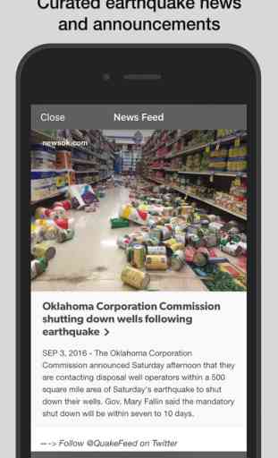
- Curated earthquake news and announcements
- Eight beautiful base maps plus plate lines
- Great educational tool
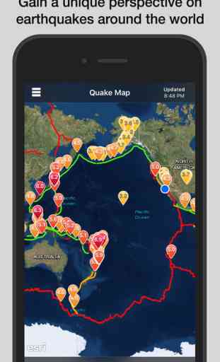
Our mapping features are truly stunning. Want a unique perspective on the quakes? View them on shaded relief or a map of the ocean floor. It will deepen your understanding - try it and you'll see what we mean!
QuakeFeed offers a variety of filter / sort options to let you see the quakes that are most important to you. Beautiful UI - check out our reviews, people love our simple, uncluttered design! And QuakeFeed is a universal app optimized for both the iPad and iPhone.
QuakeFeed is ad-supported. If you choose to purchase QuakeFeed Premium to remove ads, payment will be charged to your iTunes account, and your account will be charged for renewal 24 hours prior to the end of the current period. Auto-renewal may be turned off at any time by going to your settings in the iTunes Store after purchase. Current price for QuakeFeed Premium is $0.99 USD per year, and may vary from country to country.
Privacy policy: http://quakefeed.com/privacy.html
BASIC FEATURES
* Choose from six different USGS Data Feeds
* Push notifications for all M6.0+ quakes
* Push notifications for earthquakes near your location
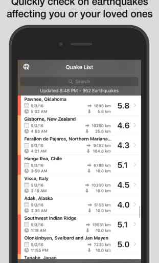
* Quakes displayed in a list or on a map
* Search, sort, or filter list
* Drill down to quake details view:
-- Map zooms to quake location
-- Magnitude, time, lat/long, distance, depth
-- Link to quake details on USGS website
-- Link to NOAA Tsunami Warning Center (if available)
-- Link to USGS "Did You Feel It?" page
* Earthquake news
* Earthquake preparedness information
* Social media integration - share via:
-- Facebook
-- Twitter
-- Email
INTUITIVE USER INTERFACE
* Color-coded map symbols with optional magnitude display
* Quake list color-coded by magnitude
* Sort list by date, magnitude, depth, or distance from current location
* Filter list or map by magnitude and/or distance from current location
* Pull to refresh list
* GPS button for zoom to current location
* Specify units for distance and depth (km or miles)
* All screens work in portrait or landscape mode
ENHANCED MAPPING CAPABILITIES
* Eight different base map options:
-- Street Map
-- Satellite Imagery
-- Imagery with Labels
-- Ocean Bathymetry
-- Topographic Map
-- Shaded Relief Map
-- Physical Map
-- Terrain Map
* Display plate lines as a map overlay
* Pinch to zoom / drag to pan
* One touch zoom in / two touch zoom out
SUGGESTIONS? QUESTIONS?
Contact us at [email protected] or visit http://quakefeed.com -- we usually respond within 24 hrs!
- Quick and very easy to use
- Nearby Alerts for earthquakes near you
- Regional Alerts for monitoring countries, US states and seismically active areas
- Choose from several different alert sounds
- Curated earthquake news and announcements
- Eight beautiful base maps plus plate lines
- Great educational tool
Our mapping features are truly stunning. Want a unique perspective on the quakes? View them on shaded relief or a map of the ocean floor. It will deepen your understanding - try it and you'll see what we mean!
QuakeFeed offers a variety of filter / sort options to let you see the quakes that are most important to you. Beautiful UI - check out our reviews, people love our simple, uncluttered design! And QuakeFeed is a universal app optimized for both the iPad and iPhone.
QuakeFeed is ad-supported. If you choose to purchase QuakeFeed Premium to remove ads, payment will be charged to your iTunes account, and your account will be charged for renewal 24 hours prior to the end of the current period. Auto-renewal may be turned off at any time by going to your settings in the iTunes Store after purchase. Current price for QuakeFeed Premium is $0.99 USD per year, and may vary from country to country.
Privacy policy: http://quakefeed.com/privacy.html
BASIC FEATURES
* Choose from six different USGS Data Feeds
* Push notifications for all M6.0+ quakes
* Push notifications for earthquakes near your location
* Quakes displayed in a list or on a map
* Search, sort, or filter list
* Drill down to quake details view:
-- Map zooms to quake location
-- Magnitude, time, lat/long, distance, depth
-- Link to quake details on USGS website
-- Link to NOAA Tsunami Warning Center (if available)
-- Link to USGS "Did You Feel It?" page
* Earthquake news
* Earthquake preparedness information
* Social media integration - share via:
INTUITIVE USER INTERFACE
* Color-coded map symbols with optional magnitude display
* Quake list color-coded by magnitude
* Sort list by date, magnitude, depth, or distance from current location
* Filter list or map by magnitude and/or distance from current location
* Pull to refresh list
* GPS button for zoom to current location
* Specify units for distance and depth (km or miles)
* All screens work in portrait or landscape mode
ENHANCED MAPPING CAPABILITIES
* Eight different base map options:
-- Street Map
-- Satellite Imagery
-- Imagery with Labels
-- Ocean Bathymetry
-- Topographic Map
-- Shaded Relief Map
-- Physical Map
-- Terrain Map
* Display plate lines as a map overlay
* Pinch to zoom / drag to pan
* One touch zoom in / two touch zoom out
SUGGESTIONS? QUESTIONS?
Contact us at [email protected] or visit http://quakefeed.com -- we usually respond within 24 hrs!
Category : Weather
Related searches